[O372]
|
Prepared by: |
|
|
|
|
Enclosure 7
[O371] OCEANOGRAPHY
I. OVERVIEW
The oceanographic, weather, and sea state conditions played a significant role throughout the Shuttle, Challenger, recovery. The proximity of the Gulf Stream axis to the surface and subsurface debris was the major complicating factor during the Search and Recovery Process. Initial recovery of the floating surface debris was made predominantly by U.S. Coast Guard, Navy, and NASA Ships, using the Coast Guard Computer Assisted Search Program (CASP) to track the surface debris. Beyond 10 days, however, the surface search ended and implementation of the U.S. Navy underwater salvage efforts began.
II. IMPACTING OCEANOGRAPHIC/ METEOROLOGICAL FACTORS
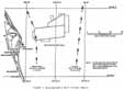
A. GULF STREAM
The axis of the Gulf Stream was generally stable in position approximately 50 nautical miles off the coast with speeds of 3.5 to 4.5 knots (Figure 1). The inner edge of the Gulf Stream, however, extended to the western edge of the salvage search box and on occasion, disrupted or terminated diving efforts due to its strength. Detailed Gulf Stream current profiles obtained from the University of Miami and the Naval Oceanographic Office were useful for planning by the Navy Salvage teams. Westward meanders in the Gulf Stream occurred on the average of twice per month with a 3- to 5-day duration. The meanders brought the axis of the stream in closer to the beach and disrupted dive operations in the shallow portions of the search area for several days.
B. WEATHER/SEA STATE
Weekly frontal passages resulting in increased winds and sea state hampered recovery operations for the first two months of operations. By April 1, 1986, the climatological spring migration to the north of the primary storm tracks created excellent diving conditions and significantly improved underwater visibility (from 5 to 15 feet). Late fall storms in the North Atlantic, however, generated long period swell waves from the north-northeast. These swell waves, when coupled with the northerly flowing Gulf Stream created a severe turbulence and silting problem in the shallow portions (less than 150 feet) of the search box. Resulting silt in the shallow areas accumulated to 18" to 24" in depth covering many smaller pieces of the Shuttle debris. Only minimal silting was observed in the deeper portions of the search box.
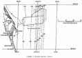
C. BOTTOM TOPOGRAPHY
Detailed Bottom Topography charts were obtained from the Woods Hole Institute of Oceanography and used throughout the underwater search. Fine to coarse sand bottoms prevailed with a gently-sloping Continental Shelf (Figure 2) which aided the recovery efforts.
III. SUMMARY
Successful recovery operations performed in the vicinity of a strong ocean current such as the Gulf Stream, is a tricky operation. The hampering winds and sea state served to further complicate the station keeping ability of the dive platforms. The documented success of the recovery teams working in this adverse environment reflects a great deal of credit upon the professionalism and dedication of the personnel and divers aboard the salvage ships.